Among Tall Peaks and Cows: Backpacking Switzerland’s Haute Route

Updated: 3 days ago

I’ve wanted to hike the Haute Route for decades. I first heard about the Skiers Haute Route when a professor of mine at Montana State University presented a slide show after skiing it back in the mid-1980s. I’ve read articles about hiking the Walker’s Haute Route since then and it’s always been in the back of my mind that I would get there someday.
Why did it take me so long? Terry and I did one European trip in our working years; we found it difficult to plan and execute, and it was expensive. With retirement we’ve finally taken the ‘it’s now or never’ perspective and started traveling abroad. We signed up for a tour of the Bernese Alps, and the idea of hiking the Haute Route fully formed; it was going to happen.
There was one caveat, I could only extend the tour by a week and have the tour company make my flights. Okay, I can make my own plane reservations, but there was a hesitancy in me that was comforted by the one-week limitation. I’m fit, but I’m 68, and I’ve been having physical issues all year. The Haute Route is notoriously difficult. Could I still do this? I honestly wasn’t sure. I settled for the eastern half of the route and set about making plans.
I was late. Terry and I had been staying in Wengen, Switzerland with the tour group for 6 days. I split from Terry and the tour to travel to Arolla, the starting point for Stage 8. It had taken much of the day. My nervous energy was boiling over. The bus stopped. It was still 2 miles to Arolla, but the sign outside my window said ‘Lac Bleu 45 minute marche.’ Lac Bleu, a small tarn, was the first notable sight on this stage of the route. I jumped out of the bus. It pulled away. What had I done? I pulled out my GPS. Instead of hiking 2 miles to Lac Bleu from Arolla, I would be hiking up and back on the same trail. Oh Well. I shouldered my pack and set out. I was going the wrong direction, but I was finally on the Haute Route.

The first day was short and easy. That’s how I like first days. It allows for inevitable late starts and provides a chance to adjust to the trail. The day ended at the Hotel de la Sage, a comfortable boutique hotel that offered a communal dinner which allowed me to introduce myself to fellow hikers.
Climbing began immediately the next day. A 4,000-foot climb to the Col de Tsate in just under four miles. It was like climbing Mount Baldy above Bozeman. I felt prepared. The 25 pounds on my back was more than I was used to when grunting up Baldy, but my legs held up.

At the top I got my first view of a new set of sharp peaks and ice fields. I had been hiking with various groups I’d met at the hotel. A mile or so below the pass one of my hiking partners pointed to the hut we would be staying in that night: the Cabane du Moiry. We had to drop into the valley before climbing 1,500 feet to reach it.
I made it into the valley and followed what I thought was the trail to the hut. There were no signs, but the trail markers were the same painted red line bounded by two white lines. After hiking for about 10 minutes, I noticed I was moving in the direction opposite of everyone else who was hiking toward the hut. I turned around. When I caught up with Sophia, Jennifer and Agogia, who I had been hiking with on and off before I got misplaced, they noted that they saw me heading off in the wrong direction but assumed I would figure it out. I jokingly said that ‘It appears that all Swiss trail markers are the same.’ Jennifer replied, “That’s right. Except for climbing trails, which have blue markers.” I did a doubletake. ‘How does that make sense?’ As we climbed red and white marked switchbacks through a boulder field in the last part of the climb to the hut. Agogia was nearby, I called out, 'How is this not a climbing trail?'

Huts are hotels, but they are basic. When I arrived maybe 50 others were busy getting settled. We wandered into our dormitories. There’s virtually no privacy, and no showers, but there's lots of camaraderie. The food is good and filling for hungry hikers and climbers. For many at the huts, ropes, ice axes and crampons are standard equipment. Huts sit high on a rocky outcrops in close proximity to glaciers and high peaks. There are huts and refuges in key spots all around these mountains. There’s even a refuge for 10 on the shoulder of the Matterhorn at 13,133 feet, a full-service hut with 40 beds at 12,565 feet on the other side of the mountain, and two more at the mountain's base.
I got misplaced again the next morning, taking the wrong one of three unmarked trails. This was my first time hiking with GPS. I got better at using it after this.
Switzerland’s backcountry is much more of a playground than Montana’s. There's more access. There are a few forest service cabins in Montana, but nothing like Switzerland’s hut system. Roads cut far into valleys and there are huts and bivouac shelters peppered all over the mountains. With the huts and in many places, trams or gondolas that reach high ridges, the flight of paragliders is ever present.
The music of bell ringing cows and sheep fill areas of the backcountry. We’d stumble upon remote herder cabins. The fear of loneliness and death of herders living in the mountains is prevalent in Swiss Mythology. There is the tale of the lonely herder who creates a woman out of straw for companionship, only to have her seduce him into staying for the winter; his hide is stretched upon the roof of the cabin in the spring.
Past the cows, we climbed to the Col de Sorebois, then began a long downhill, 6,000 feet in total for the day, and entered the village of Zinal. Just when you think that tonight’s view cannot possibly measure up to the one you had last night on the precipice of a glacier, the sharp peaks above Zinal come into view. Wow! The accommodation was comfortable and included hot tub access: ahhhh.
First view of the peaks of the Zinal Valley; view from downtown Zinal
The next morning’s climb was relentless: a 4,000-foot ascent of Forcletta pass in 6.3 miles. Partway down the other side I’d be separating from the main pack of Haute Route hikers to walk to Turtmann Hut instead of dropping into the town of Gruben. At first, I was bummed. I was enjoying the camaraderie of the trail, but once I set off on the side trail to Turtmann—marked white and red of course—I found myself enjoying the solitude. The trail was well marked, but less heavily used. A water diversion engineering project was buried beneath it. Creeks ran down the mountain side and disappeared at the trail. There were concrete vaults buried in the trail where water could be heard rushing, but the engineering was so well hidden I found its full extent impossible to discern. The trail itself looked natural, it was dotted with boulders and rockslides, there was even a cliff to be worked around. The question, how could they have laid a pipe underground to move water and leave no sign on the trail other than the vaults perplexed me. At the hut, I asked this question of another hiker who had come the same way; he was equally mystified.
Spires above Turtmann glacier; Turtmann hut on ridge middle left
Turtmann was a spectacularly located hut that offered absolutely no privacy, no showers, and my sleeping accommodation was on the comical side: outside, stuffed into a storage container with five others in three bunk beds. I’m guessing we were in overflow; I had a top bunk. But as one of my bunk mates laughed the next day, ‘you just go with it.’ I agreed, then I apologized to his wife, another top bunk mate, for grabbing her foot instead of the ladder in the middle of the night.
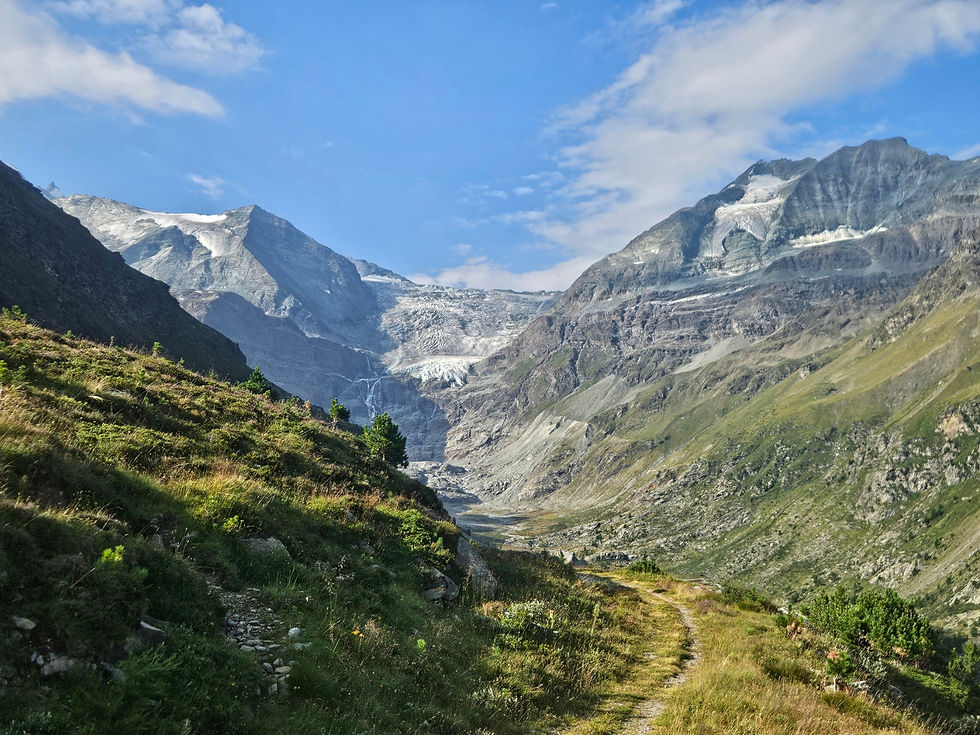
There was one thing about Turtmann that has nagged me since I got home. I met a few folks at the hut who were climbing Ussers Barrhorn. At 11,840 feet, it is considered the highest hiking mountain in the Alps. I was so close to it, but I didn’t know. The view from there is incredible encompassing Weisshorn, Dom and the Mount Rosa massif. There’s also an insane sky run to the top: 23.8 kilometers (14.8 miles) while climbing 3,176 meters (10,420 feet). It was held a few days before I was there. I’m old, it would hurt so badly to try and do this run, but I’m already contemplating whether I can pull it off next year.
Even if I had known about Ussers Barrhorn it might not have been possible. I had a long day of hiking getting to the hut and another long day ahead once I left. This was my last big day; it was incredibly difficult; it was incredibly amazing. It was a long hike, nearly 15 miles. The uphill was only about 3,000 feet. That took me to Augstbord Pass. There I said goodbye to the Turtmann Valley and entered the Mattertal Valley, home of some truly gigantic peaks including the Matterhorn. I remember once again enjoying the solitude on my hike to the pass. I was moving slowly today, feeling mellow, but I was bummed that there was no one at the pass to chat with. I could see the trail ahead; it cut through a boulder field that would take me an hour of careful stepping to get across. I was tired, mellowness was quickly transitioning to exhaustion. That morning, when I awakened in the shipping container, my Garmin told me my training level was ‘Strained.’ I was feeling the effect of five days full of effort.
I kept hiking past the boulder field until I finally turned a corner and was overlooking the Mattertal Valley. Wow! Stunning! I’ve been in many beautiful places, my home of Bozeman included, but I had never seen anything like this. Mettelhorn (11,188 feet) and Weisshorn (14,780 feet) were on my side of the valley. Mettelhorn stood closest; it has a knife edge ridge that leads to a sharp peak. Weisshorn is mostly buried under ice; I conjured up a pinheaded man dressed in a white tux with black tie to describe it. Directly across the valley stood 14,915-foot Dom, a massive peak buried in ice. The Mount Rosa Massif, topping out at 15,203 feet, stood at the head of the valley with glaciers pouring down from its many peaks. Only the Matterhorn remained hidden from this viewpoint. The valley is deep, St Niklaus, my destination for the evening sits at 3,675 feet magnifying the prominence of these peaks.
Dom; Mt Rosa; Mettelhorn and Weisshorn
With the view burned into photos and memory, I continued to descend to St Niklaus. This was the longest, most difficult descent of the trip. Some of the trails here are truly amazing. Cliffs shadow the valleys; small breaks between cliffs are the only places to squeeze trails, so one descends sets of steep switchbacks, until reaching an impassible cliff band then the trail is squeezed along the top until another gap allows further descent. I'm hiking down, down and down endlessly when I pop out of the woods to find a busy restaurant. So this is the village of Jungen that's labeled on my map. It sits atop a cliff and is reachable only by tram. There were backpacks strewn about. I added mine to the jumble and stopped for a sparkling apple cider. This is part of the playground aspect of Switzerland. There are so many trams, so many impossibly placed villages and so many paragliders lifting off. I watched hikers grab their gear after they ate and walk down to the tram wisely avoiding the bone jarring descent into St Niklaus. I am not that wise. I shouldered my pack and continued pounding the crap out of my knees.
My full descent for the day added to 7,600 feet. Arriving in St. Niklaus was anticlimactic. It was much bigger than the small villages of la Sage or Zinal. As I walked a mile or so alongside railroad tracks; I felt out of place. I found my hotel, checked-in, ate and passed out.
Breakfast the next morning was filled with trekkers. Okay, I’m not out of place. I ate heartily, chatted with a few familiar faces and set out for my last day. Last evening I thought today’s hike would be pointless; I would be starting and ending in the Mattertal Valley. I was hiking to the village of Randa a few miles up the valley and only two stops away by train, but to get there I would be climbing 4,500 feet and descending nearly as much over a distance of 10.7 miles.
I’m glad I did the hike. It was steep switchbacks between cliff faces, up the western flank of Dom, named for Canon Berchtold, the first person to survey the area in 1833, but it was shaded in beautiful forest. Boulders gave character to the trail as did long stretches of soft pine needles. The climbing was relentless but cool air kept me and many other hikers going. Europa Hut sat just past the high point on the trail for the day. No roads, no tram, just a beautiful hut with restaurant more than 4,000 feet above the valley. I expect everything is transported in and out by helicopter as is the case at Cabane du Moiry and Turtmann hut.
Trail to Europa Hut; an impossibly placed cluster of homes
The hike down was hard on tired legs, but it was the last one and it went quickly. There was a hotel next to the trail station. I stopped for a sparkling apple cider while I waited for my train. Judith came down a few minutes later. We had chatted on two passes in the past few days and I told her I'd buy her a beer if we ever saw each other in a town; she chose sparkling apple cider--it's a thing in Switzerland. It was great to see a familiar face. We sat together sharing stories from our day. She was hiking to Zermatt the next day, I was not. My train pulled up and I was whisked to Zermatt.
Europa Hut; a quarter mile long suspension bridge over a runoff area from Dom
Switzerland’s attitude toward mountains both for living and adventure purposes is tilted toward access. In large part, I believe this is because of how deep the valleys are. Towns have been built in relatively warm valley environments, but the valleys are narrow. For the towns to expand they must climb the mountain flanks where previously only herders roamed. Some towns are reachable by switch backing roads; some by cog railways threaded through niches in cliffs; some are only reachable by tram, and it appears some hamlets can only be reached by trail. Then there’s the occasional house perched in the most precarious of places. Other than helicopter, I wasn’t sure it could be reached at all.
In Swiss Mythology, white death haunts remote houses and valley towns in winter darkness. Exposure of these newer villages is limited by locating them on meadows beneath forests where avalanches haven’t roared, or by bracing the upper mountains with metal snow nets. It's an engineered world.
Word in the huts was that climate change is quickly shrinking the glaciers. Glaciers that appeared huge to me were already much diminished. Last ski season was poor here as it was back in Montana. It's beautiful, but everywhere the world is struggling with heat, wildfires and lack of snow.
It was an amazing adventure. Different than any experiences I’ve had in the US, and different than my hut hike in Iceland last year. It was physically rigorous, but I managed, and it was worth it. With enough effort and some duct tape, maybe I’ll be able to keep this aged carapace together long enough to come back and hike the western half of the route.


Amazing story and pictures! No trams for my 'bro! The photo with the cluster of houses literally blew my mind. How does one live in such a place?! So glad you got to realize this life's dream.
Thanks, Chuck, for sharing this beautiful report of your trip. It's been a long time coming and sounds like it was totally worth it and that you were well-prepared. Jie and I also took a wrong turn (perhaps the same one?) approaching Cabane du Moiry in 2013, except I think we gained almost 1000 feet of elevation before realizing our mistake. Jaw dropping views at the crest of each pass, but I agree the first glimpses of the Mattertal Valley are something else entirely. I'm super happy for you that you finally made it to the Haute Route and wouldn't be surprised at all if you made it back in the near future. The mix of remoteness and accessibility of…