Hoping for Hollowtop
- charlesjromeo

- Oct 13, 2025
- 5 min read
Updated: Jun 1

As we reached the top of the peak the cloud mass that had already built to the north closed in on us: there would be no views. It was late summer 1984, Terry and I were out with Cindy and Peter, another couple of Bozemanite buddies. We had made it to Hollowtop Lake in the Tobacco Root Range the evening before. I remember the weather as having been stormy, so we never got a good view of peaks in the area; now that we were on top, we didn’t have a view of anything.
We made our way back to camp as a wave of rain set in; we quickly took the camp apart and started down the trail. There had been things about the climb that confused us: the top wasn’t hollow, and Hollowtop had a large snowfield at the top that was easily visible from Bozeman, some 50 miles away. The mountain we climbed had a snowfield at the top, its shape looked about right, but it didn’t seem nearly large enough.
The clouds lifted as we drove away. We stopped; all got out and looked back at where we had been. We had climbed the wrong mountain; we weren’t off by just one peak, but by two. We had missed Hollowtop and Mount Jefferson directly to its south, and climbed the shorter, easier Horse Mountain.

This memory has haunted me for more than 40 years now. How could we have climbed the wrong mountain? At 10,604 feet Hollowtop is the tallest peak in the Tobacco Roots: climbing it was a worthy venture. In my memory, 10,226-foot Horse Mountain was an insignificant climb.
I have been determined to get back into the Tobacco Roots to climb Hollowtop. I finally set out, trail running this time, on Friday, October 10. Fall has been amazing in Bozeman: cool mornings, tee shirt afternoons. Perfect weather for some big days of peak bagging. But periods of perfect weather always have an expiration date, and this day was forecast to be the last perfect day.
I collected Forest, my trail running Bestie, and his pal Zuko, in the morning as I set out. It was raining when I got up in the morning, raining as we drove to the Tobacco Roots, and misting as we started running. The weather was changing; the forecast had been belatedly updated with morning rain, but still showed clear skies dominating the day.
We were only a half-mile up the trail when a moose crossed about 50-feet in front of us. I stopped our threesome. We were in mixed forest and meadow; I moved us perpendicularly to the trail into the meadow. I could see the moose; she was a huge beast with white fur on the lower half of her back legs; she was stopped, staring as us. We were a curiosity. The Tobacco Roots are less well traveled than the mountains closer to Bozeman; I don’t expect that she was habituated to the presence of humans and dogs. I worked quickly: out came the bear spray, a leash for Forest, the remote-control training device for Zuko. These items along with my trekking poles were in my hands as we made our way back to the trail. The moose didn’t move; she followed us with her eyes as we moved up the trail. Zuko caught her scent, started in her direction, but turned back when I yelled “Zuko No!” and hit the sound button on the remote-control.

When we were about 100 yards past the moose I put everything away, and we continued. Crisis averted.
The trail to Hollowtop Lake ascends steadily over its 4.4 miles. Once there, across the lake, I had a view of all three mountains: Hollowtop, Jefferson and Horse. The thought crossed my mind that maybe it wasn’t all because of the weather 41 years ago. Maybe I just want to remember it that way to reduce human error in the decision to climb Horse—most likely my human error. It’s possible that we had clear skies, a perfectly wonderful evening and a starry starry night. From Hollowtop Lake, the eponymous mountain doesn’t look anything like the mountain we can see from Bozeman: only its south wall is visible. Horse looks more like Hollowtop than Hollowtop does from the lake. Could it be that I simply angled the map wrong and directed us to the wrong mountain? Naaah!

There were cirques: one between Hollowtop and Jefferson, and another between Jefferson and Horse. I had looked on Summit Post for information about routes. The only entry said that they climbed Jefferson first and hiked the ridge to Hollowtop. But which side of Jefferson? The south face of Hollowtop that I could see from the lakeshore had lots of steep granite. I couldn’t see the north face of Jefferson, but the cirque is tight suggesting that it too was steep; what I could see of the southeast face looked climbable. I would have to see where the climbers trail took me.
The official trail ends when it reaches the lake. I started my way around the lake heading west planning to curve around the western edge of the lake to make my way into the cirque between Jefferson and Hollowtop, but me and my 4-legged partners came to a huge blowdown area that blocked the trail. I backtracked and found what I hoped to be a climbers’ trail that headed into the cirque between Horse and Jefferson. The trail petered out, but I continued making my way toward the south face of Jefferson.
I saw a line that would go—for me, but it was full of blocky scree that would be dangerous for the dogs to climb. There was also the weather to be considered. Clouds were racing above the peaks. It was blowing hard up top; the last perfect day was proving to be less than perfect. If we did climb the scree, we would have a long ridge hike to the peaks of Jefferson and Hollowtop, unlikely to be feasible in the winds I was sure we would experience.

I turned to the south and faced Horse Mountain: it was mostly grass tussocks with some scree, safer for the dogs and me, and we could likely hit the peak directly so to be up and off it quickly. My shoulders sagged momentarily. I was hoping for Hollowtop; I didn’t want to climb Horse again, but we started up. It wasn’t an easy climb: steep class 2, and with the morning’s rain, everything was wet and slick. It was breezy in the cirque, and once we reached the crest, we were hit by a steady blast of wind. I kept the poor doggies up there for about 5 minutes hoping for a short break in the onslaught that would allow me to hold my phone steady to take pictures. It didn’t happen. I took shots the best I could and took in the range. What I could see was rugged and beautiful. My first thought was that it reminded me of the Spanish Peaks: lots of beautiful mountains, with deep forested valleys.


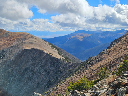
A view from the top and one from just ot of the wind
Back at the lake, I took note that if I get another chance to come back here, I will have to work my way into the cirque between Jefferson and Hollowtop. It’s not easy to get in there. There’s thick forest, and the cirque is guarded by two lakes with cliff bands in between. Above the lakes, the climbing promises to be steep, maybe dangerously so. No matter. I'll be able to climb it; I'm sure I can. Or, ... maybe I can just angle the map like this ...


Comments